日本の地図、伊能忠敬について
館長あいさつ
こんにちは。この度は見に来てくださりありがとうございます。館長です。
皆さんは伊能忠敬と聞いて何を思い浮かべるでしょうか。日本地図の測量をした人と真っ先に思いつくかもしれません。
今回はそんな伊能忠敬、日本地図の歴史について深くしれたら良いなと思って楽しんでご覧ください。
この展示について
この展示を通して少しでも日本地図に対する興味が沸いてもらえることがこの展示の趣旨です。
日本地図の歴史
- Tadataka Ino
A geographical surveyor of the Edo period who created the first map of Japan using surveying techniques
館長からの一言
日本全国を歩いて測量し、かなり正確な日本地図を作った人です。55歳から測量を始め71歳まで測量をし続けました。一生でだいたい地球一周(4万キロ)を歩いたと言われています。
- Ino Maps
The first scientific maps of Japan based on actual measurements, created from surveys by Tadataka Ino and completed by Kageyasu Takahashi
館長からの一言
伊能忠敬が17年間をかけて、その後に高橋景保と弟子たちで完成させた日本地図です。海岸線や道路、名所などを正確に描き、現在の日本地図と比べても見劣りしない高い精度を誇ります。
- Nihon yochi rotei zenzu (Route Map of Japan)
A map of Japan published in the Edo period, the first map in Japan marked with longitude and latitude
館長からの一言
江戸時代後期に長久保赤水が作成日本地図です。経緯線が入っている精巧な地図で伊能図が出るまでは最も普及していました。
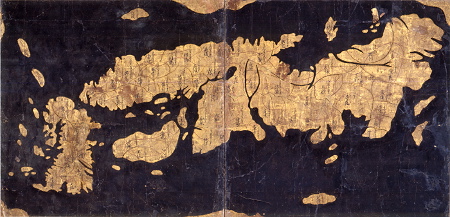
- Gyoki Maps (Gyoki-zu)
A general name for maps of Japan created in the Edo period or earlier
館長からの一言
奈良時代に行気が作成したと伝えられている地図です。1400年頃から400年ほど使われていました。日本輿地路程全図や伊能図が出るまでは日本行基図は標準的な日本地図でした。
- Japanese Map
東京国立博物館,Tokyo National Museum
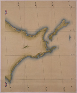
<p>In the early-19th century, Ino Tadataka surveyed the entire nation of Japan on foot and produced a detailed map of Japan. This is a famous episode in Japanese history. Tadataka made maps at three different scales, small, medium and large. This is his medium-scale map, which represents the Japanese Archipelago at 1:216,000 scale across eight charts. It accurately records land elevation and bearing, and mountains, rivers, roads, harbors, castles, temples, and more are marked on it with minute labels. Its precision compares favorably even to present-day maps. Its careful lines and colors make it impressive as a painting as well.<br /><br />Ino Tadataka embarked on his nation survey in 1800 at the age of 56, far from young for the time. He divided Japan into areas and completed the project over the course of 17 years and 10 expeditions. The survey teams led by Tadataka traveled all of Japan on foot carrying specialized equipment, produced maps of each region based on the results of their survey and submitted their maps to the samurai government in Edo. Even after Tadataka’s death in 1818, his apprentices carried on his work compiling the results of his surveys into maps. In 1821, they completed the 255-page compilation and submitted it to the samurai government as a finished work, with three pages for the small map, eight for the medium map, and 214 for the large map. The edition they submitted to the government was, unfortunately, destroyed by a fire in 1873, but copies made based on the same survey data and maps submitted before the compilation survived. The Tokyo National Museum has a number of these high-quality copies and pre-complete-edition maps in its collections. This map is one of them. It was previously passed down through the Matsudaira clan of Yoshida Domain, Mikawa Province in present-day Aichi Prefecture. At the time of Tadataka’s survey, a member of this clan held an important post in the samurai government.</p>
館長からの一言
伊能忠敬たちが約17年間かけて実測した全8枚で構成された地図です。縮尺は21万6千分の1で、蝦夷東半、蝦夷西半、東北、関東、中部近畿、中国四国、九州北半、九州南半に分かれている。

展示を見終わった人へ
この度は「日本の地図、伊能忠敬について」をご覧くださりありがとうございました。この展示を通して日本地図の歴史や伊能忠敬について関心が沸いてくださると幸いです。ここまで見てくださりありがとうございました。
館長より