Gyoki Maps (Gyoki-zu)
A general name for maps of Japan created in the Edo period or earlier
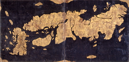
Although legend has it that such maps were first made by the Buddhist priest Gyoki, his name seems to have been added after the maps were originally created. A Gyoki map shows the whole of Japan, with provinces depicted in outline loops centered around the Kyoto capital region and showing the seven major highways, the rankings of provinces, and their position in relation to one another. These maps were made and used from the Heian period through the early Edo period (8th to 17th centuries). Introduced to the West at the end of the 16th century, Gyoki maps were the basis for the maps of Japan developed by Abraham Ortelius and others in Europe. The most well known maps of this type are the Yochi Map (805), which depicts Kamomioya Shrine (familiarly known as Shimogamo Shrine); the maps contained in the ancient Japanese encyclopedia Shugaisho (Collection of Miscellanea) from the end of the Kamakura period (around the 14th century); the “Nansenbushu Dainihonkoku shoto zu” (Orthodox Map of Great Japan in Jambudvipa) at Toshodai Temple; a fan-shaped map owned by Hideyoshi Toyotomi; and a folding screen with a map of Japan at Hosshin Temple in Obama, Fukui Prefecture.
Related People, Things and Events
Books
Related Works
海外で製作された日本図
External Links
兵庫県神戸市にある市立博物館。行基図である『日本地図屏風』など多くの古地図を収蔵している。
茨城県つくば市にある国土地理院のホームページ。「古地図コレクション」のページでいくつかの行基図が検索できる。
References
- 加藤友康 [ほか]編,吉川弘文館
- 歴史学研究会 編,岩波書店